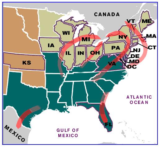
The
above map and the corresponding link contain information on some of the
many routes that slaves took to escape slavery. Your task is to locate
these places (or relatively close) and see exactly how many kilometers
the slaves had to trek, in order to reach freedom. Recreate the map on
your own and label the red arrows with roughly how long each trek took.
A site like Google Maps
may be a helpful tool in helping you complete this task. Also on a
separate sheet, use the map, as well as additional research to help
answer the following questions:
1. Which directions did the slaves go to escape slavery?
2. Why were slaves running to Florida, even though slavery was legal there?
3. How many states was slavery legal in? How many states was it illegal in?
4. How did the slaves escape slavery, what was their mode of transportation?
1. Which directions did the slaves go to escape slavery?
2. Why were slaves running to Florida, even though slavery was legal there?
3. How many states was slavery legal in? How many states was it illegal in?
4. How did the slaves escape slavery, what was their mode of transportation?
